


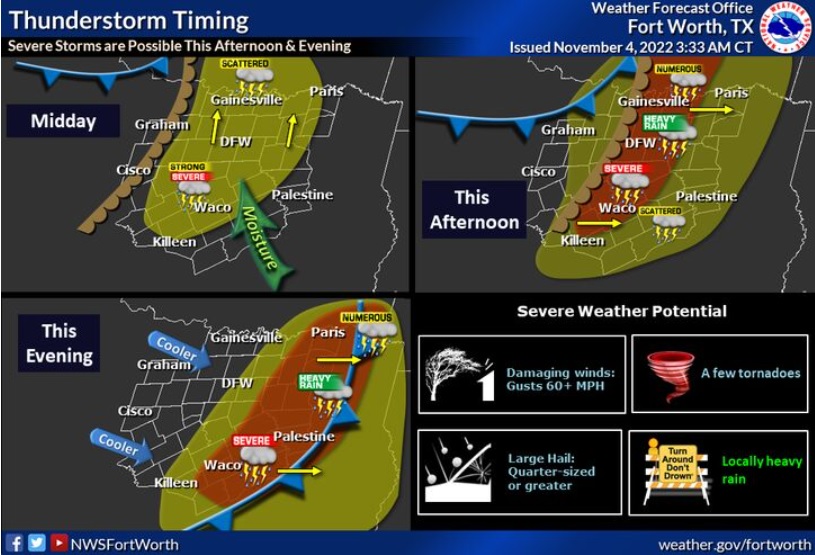
Severe weather is expected across North Texas on Friday; late morning through afternoon. The storms are expected to accompany the leading edge of another arriving cold front, and will move east affecting East Texas through Friday evening and the overnight hours. Tornadoes, strong winds, heavy rainfall and large sized hail are all possible with this system.
Today
A chance of showers and thunderstorms before 10am, then showers likely and possibly a thunderstorm between 10am and 1pm, then showers and thunderstorms after 1pm. Some of the storms could be severe. High near 78. South wind 15 to 20 mph, with gusts as high as 35 mph. Chance of precipitation is 100%. New rainfall amounts between three quarters and one inch possible.
Tonight
A 40 percent chance of showers and thunderstorms before 10pm. Some of the storms could be severe. Mostly cloudy during the early evening, then gradual clearing, with a low around 48. West northwest wind 10 to 15 mph, with gusts as high as 25 mph.
Saturday
Sunny, with a high near 69. Light and variable wind becoming south 5 to 10 mph in the afternoon. Winds could gust as high as 20 mph.
Saturday Night
Clear, with a low around 52. South wind 5 to 10 mph, with gusts as high as 20 mph.
Sunday
Sunny, with a high near 78. South wind 5 to 10 mph, with gusts as high as 25 mph.
Sunday Night
A 20 percent chance of showers and thunderstorms after 1am. Partly cloudy, with a low around 64. South southeast wind around 5 mph.
Monday
A 50 percent chance of showers and thunderstorms. Partly sunny, with a high near 82. South southeast wind 5 to 10 mph, with gusts as high as 20 mph.
___
Meantime, the Texas Division of Emergency Management (TDEM) has activated the following resources to support severe weather response operations across the state:
- Texas A&M Engineering Extension Service (Texas A&M Task Force One and Texas Task Force Two): Boat Squads and Urban Search and Rescue Packages
TDEM has the following state resources on standby to respond if conditions warrant:
- Texas A&M Forest Service: Saw Crews and Incident Management Teams
- Texas Parks and Wildlife Department: Boat Teams to support water rescue operations
- Texas National Guard: Transportation platoons and helicopters with hoist capability
- Texas Department of State Health Services: Texas Emergency Medical Task Force Severe Weather Packages
- Texas Department of Public Safety (Texas Highway Patrol): Helicopters with hoist capability
- Public Utility Commission of Texas: Power outage monitoring/coordination with utility providers in the threat area.
- Texas Commission on Environmental Quality: Personnel to monitor drinking water, wastewater and air quality
- Texas A&M AgriLife Extension Service: Disaster Assessment and Recovery Agents
- State Mass Care Coordination
Texans are urged to follow these flood preparedness and safety tips during severe weather events. For flood safety tips, visit ready.gov.
(Copyright, All Rights Reserved, WBAP/KLIF 2022)