


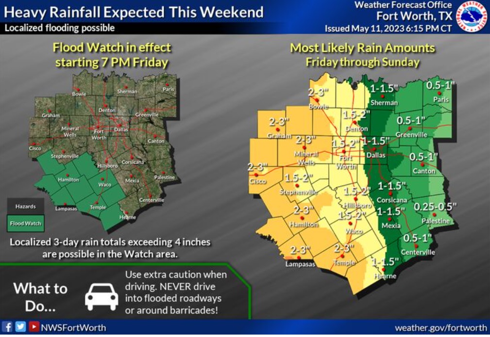
Widespread rainfall is expected over the upcoming weekend. Rain amounts will range from 0.5-1 inch in East Texas to 2-3 inches west of I-35. A Flood Watch has been posted for western portions of Central Texas where localized 3-day totals may exceed 4 inches.
Friday
A 40 percent chance of showers and thunderstorms, mainly after 1pm. Some of the storms could be severe. Mostly cloudy, with a high near 87. South wind 10 to 15 mph, with gusts as high as 20 mph.
Friday Night
A 50 percent chance of showers and thunderstorms. Some of the storms could be severe. Patchy fog after 5am. Otherwise, mostly cloudy, with a low around 71. South southeast wind 10 to 15 mph, with gusts as high as 20 mph. New rainfall amounts between a quarter and half of an inch possible.
Saturday
Showers and possibly a thunderstorm. Some of the storms could be severe. Patchy fog before 9am. High near 83. Southeast wind 5 to 10 mph. Chance of precipitation is 80%.
Saturday Night
Showers and thunderstorms likely before 10pm, then showers likely and possibly a thunderstorm between 10pm and 1am, then a chance of showers and thunderstorms after 1am. Mostly cloudy, with a low around 69. Southeast wind 5 to 10 mph. Chance of precipitation is 60%.
Sunday
A chance of showers and thunderstorms before 1pm, then showers likely and possibly a thunderstorm between 1pm and 4pm, then showers and thunderstorms likely after 4pm. Mostly cloudy, with a high near 83. Southeast wind 5 to 10 mph. Chance of precipitation is 60%.
Sunday Night
Showers and thunderstorms likely, mainly before 7pm. Mostly cloudy, with a low around 68. Southeast wind 5 to 10 mph becoming north after midnight. Chance of precipitation is 60%.